Earth Science Digital Image Library - Kaaterskill Falls
Earth Science Digital Image Library - Kaaterskill Falls
Grade Levels
5th Grade, 7th Grade, 8th Grade
Course, Subject
Related Academic Standards
Topic

Erosion
Description

Kaaterskill Falls is the highest waterfall (260 feet high) in New York State. The ledge breaking the falls represents the contact between the Manorkill Sandstone (Middle Devonian Hamilton Group) and the overlying sandstone and shale of the Late Devonian Oneonta Formation (Catskill or Genesee Group). Kaaterskill Falls is along one of the headwater streams of the larger Kaaterskill Clove, a great ravine that has expanded as stream erosion has carved into the steep Catskill Mural Front. This headwater stream erosion began following the retreat of the Pleistocene glacier. Geologists have postulated that if the glaciers retreated from this area about 15,000 years ago then the rate of headwater migration is at an amazing one foot per year.
Location
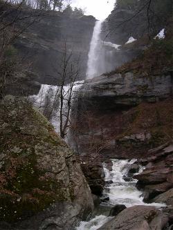
Kaaterskill Falls, Greene County, NY.
Credits
With support from the Center for Applied Technologies in Education, The Earth Science Digital Library is an initiative authored by Russell Agostaro, Newburgh Enlarged City School District, Newburgh, New York.
Description
The Earth Science Digital Image Library is an archive of quality digital images for teacher and/or student reference in their studies of Earth Science. For additional information about the image, please click on a link below: